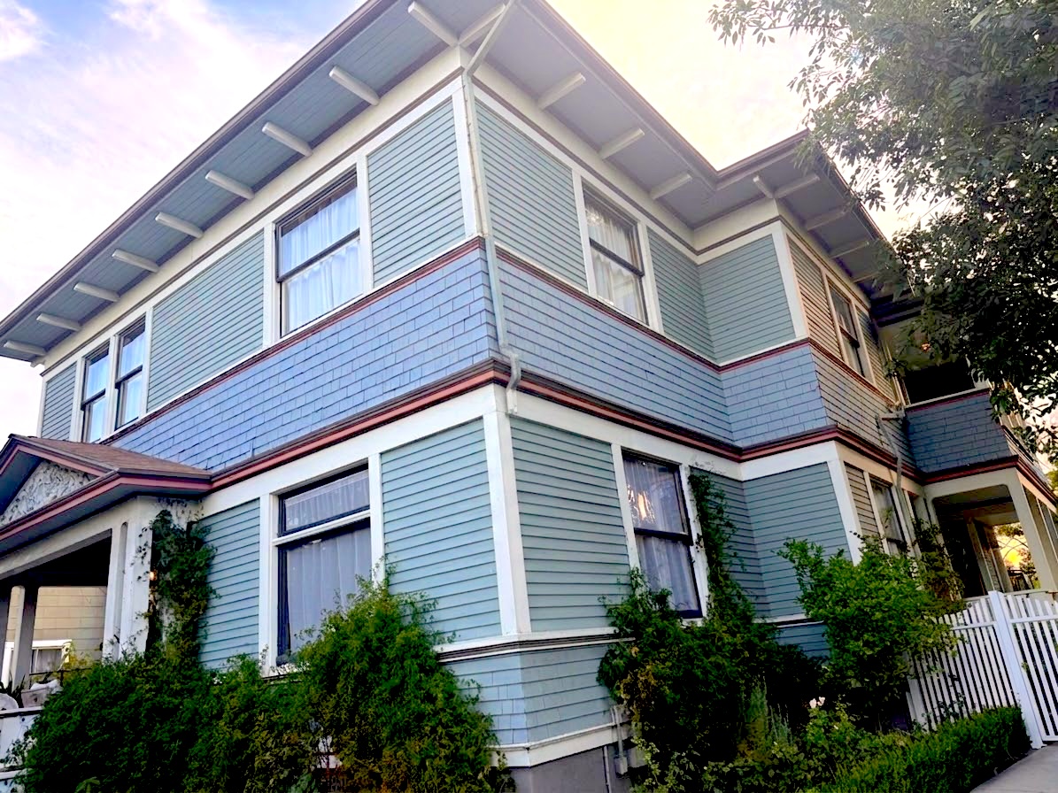

1284 Wexford Road, Los Angeles, CA
A 6-bedroom, 4,617-square-foot Victorian home built in 1885 in the heart of Angelino Heights, 1284 Wexford Road sits on a 13,570-square-foot lot — per county GIS parcel data — within LA's first Historic Preservation Overlay Zone and carries an active Mills Act contract on the City's inventory, a combination that brings meaningful property-tax benefits and a stricter preservation regime that transfers with the sale. The home is steps from the Innes Stairway and a short walk down to Sunset's dense restaurant and café corridor, yet the hilltop block itself remains quiet, residential, and deliberately slow.
The Property
A rare survivor from Angelino Heights' original Victorian building boom, this house was built in 1885 per the LA County Assessor roll — the same decade that produced the neighboring Eastlake and Queen Anne houses on Carroll, Douglas, and Edgeware. At 4,617 square feet and six bedrooms per the LA County Assessor roll, the scale is genuinely substantial; one bathroom per the roll is the figure on record, and buyers should verify whether any bathroom additions have been made with or without permits. The lot measures 13,570 square feet per county GIS parcel data — roughly a third of an acre on the hilltop, generous for this part of the city.
- APN: 5412-008-019
- Year built: 1885, per the LA County Assessor roll
- Size: 4,617 sq ft main structure, per the LA County Assessor roll
- Bedrooms / Bathrooms: 6 bed / 1 bath, per the LA County Assessor roll
- Lot: 13,570 sq ft, per county GIS parcel data
- Total assessed value: $462,000 per the LA County Assessor roll — this is the Prop 13 tax basis, not a market valuation; the tract's median home value is $892,000 (ACS 2024), and individual Victorians in this district have sold well above that figure
- Zoning: RD2-1VL-HPOZ — a limited-density residential zone with HPOZ overlay
- HPOZ: Angelino Heights, designated August 10, 1983 — LA's first
- Mills Act contract: On file
Historic Designations and What They Mean for a Buyer
The property sits inside the Angelino Heights HPOZ and carries a Mills Act contract on the City's inventory. These are two distinct regimes administered by two different bodies, and both transfer with the sale.
The Mills Act contract goes further. Under contract, the owner answers to the LA Office of Historic Resources rather than the HPOZ board, and that review reaches interior work as well as exterior and street-facing changes — where HPOZ review generally reaches only the exterior. A buyer told only that "exterior alterations require design review" would reasonably conclude the interior is unrestricted; on this property, it is not. The trade-off is a meaningful one: the contract restricts the assessed value to an income-based calculation, which can substantially reduce the annual property-tax bill relative to a standard Prop 13 basis. The contract status and the owner's current maintenance obligations should be confirmed with the LA Office of Historic Resources before close — the City's inventory layer carries no status column.
Permit History
No permits are on file for APN 5412-008-019 in the LADBS digital system, which covers 2013 to the present. This is a coverage gap, not a clean history: a house of this age will have had substantial work over 140 years, and those records exist only in LADBS's scanned archive. A formal records request to LADBS is recommended before close — it is the only way to confirm the scope and permit status of any prior alterations, additions, or systems upgrades.
The Neighborhood
Wexford Road sits on the quiet residential crown of Angelino Heights, where the streets are lined with Victorian and Eastlake houses — the densest concentration of intact late-19th-century residential architecture in Los Angeles — and daily life moves at the deliberate pace of people walking slowly past porches and gables. There is no commerce on the hill itself; coffee, groceries, and dinner all mean the short walk down to Sunset Boulevard, which is close enough to feel like an amenity rather than a concession. What holds this place together is policy as much as character: the Angelino Heights HPOZ, the city's first Historic Preservation Overlay Zone, was established on August 10, 1983, and its rules — along with more than 30 individually designated Historic-Cultural Monuments in the district — have kept the neighborhood looking the way it does.
Development Watch
A live preservation controversy is worth knowing about. A proposed project under state housing law would add 11 three-story townhomes at 1467–1471 West Ridge Way, within the Angelino Heights HPOZ. State law SB 1123 allows up to 10 townhomes per parcel in qualifying subdivisions under ministerial (no discretionary hearing) approval, and opponents — organized as Save Angelino Heights — have challenged whether the HPOZ overlay limits that entitlement. The LA Conservancy has also weighed in. The outcome will matter to everyone with a stake in the district's character; buyers should monitor it before close.
Schools
Public school assignment at this address runs through LAUSD's Logan Academy of Global Ecology for grades TK–8, a campus with deep roots in Echo Park and a standout student-growth record. High school assignment opens onto a broad menu of specialized Contreras Learning Center pathways, Belmont SH, and Roybal LC. For families exploring beyond the assigned schools, Betty Plasencia's STEAM Magnet and Downtown Magnets High School are the most compelling nearby options — though each requires an application through LAUSD's choices process.
Assigned Elementary & Middle: Logan Academy of Global Ecology
Assigned to Logan Academy of Global Ecology (TK–8, 1711 Montana St.) and Logan Academy at the middle level, per LAUSD boundary data. The school describes itself as offering a TK through 8th-grade Dual Language (English–Spanish) program "that attracts students from across our district." The campus has served Echo Park since 1888.
Logan Academy carries a GreatSchools overall rating of 8/10 ("Above average," top 24% in California) — sourced directly from greatschools.org. The breakdown shows meaningful contrast within that number:
- Student Progress: 10/10 — the school's strongest signal, reflecting academic growth that outpaces comparable California schools.
- Test Scores: 5/10 — proficiency rates trail state averages: 27% in math (state: 37%), 38% in English (state: 49%), 26% in science (state: 33%).
- Attendance: 64% of students present nearly every school day, versus the state average of 81% — a substantial gap worth discussing with the school directly.
Other School Options
Downtown Magnets High School (0.7 miles, Temple-Beaudry) earned a 2023 National Blue Ribbon Schools Award from the U.S. Department of Education. The school offers Business, Electronic Information, and IB pathways. Enrollment is via LAUSD's magnet choices process.
Safety
The surrounding half-mile logs 873 crime incidents recorded by LAPD since January 1, 2026 — a count describing the neighborhood's broader activity, not this block specifically. No code enforcement cases appear on Wexford Road, the property's own street, in the ZIP 90026 dataset of 77 cases citywide over the past 12 months. The top categories in the half-mile radius are property crimes, with vehicle theft and petty theft the most common; violent crime exists but is significantly outnumbered.
Crime breakdown — 0.5-mile radius, 2026 to date:
| Category | Incidents |
|---|---|
| Petty Theft | 141 |
| Grand Theft Auto | 86 |
| Vandalism ($400+) | 65 |
| Battery on Person | 60 |
| Grand Theft | 44 |
The pattern here is consistent with a dense urban corridor: property crimes dominate, concentrated on and near Sunset Boulevard and the Echo Park Lake area rather than the interior Angelino Heights streets. The most recent samples in the data include incidents at Dodger Stadium (0.28 miles) on game nights — battery and petty theft tied to stadium crowds — and a residential burglary 0.29 miles away. Wexford Road itself is a low-traffic hilltop residential street; the Sunset corridor, a short walk downhill, accounts for most of the area's commercial-zone activity.
Nearest urgent care is Sunmoon Urgent Care, approximately a 3-minute drive. L.A. Downtown Medical Center, a licensed general acute care hospital, is approximately a 5-minute drive; PIH Health Good Samaritan Hospital is approximately an 8-minute drive.
Hazards & Zones
This parcel carries a mix of meaningful and benign designations; the fire rating and the methane buffer zone are the two items that require a buyer's direct attention.
- Fire Hazard Severity Zone: High, per CalFire — the zone classification that applies to this parcel. Homes in this zone are subject to Class A or B roofing requirements on replacement, and the nearby permit record confirms neighbors are actively complying. The designation does not mean wildfire is imminent or likely for this urban hilltop; it means the parcel is subject to the state's heightened construction and vegetation standards.
- Methane Buffer Zone: This parcel is in a City of LA Methane Buffer Zone — an oil-field legacy designation that covers large parts of the city and is a required seller disclosure. For new construction or major remodels, building code requires methane-mitigation measures (venting, barriers). It is common across the basin and routinely addressed through standard engineering; it is not a bar to financing or habitability.
- Flood Zone: FEMA Zone X — Minimal flood hazard, per FEMA.SourceWEBmsc.fema.gov · National Flood Hazard Layer No special flood insurance is federally required.
- Alquist-Priolo Earthquake Fault Zone: Not in a fault zone, per the CA Geological Survey. This does not mean the property is seismically risk-free — all of Southern California carries background seismic risk — but no mapped active fault trace runs through this parcel.
- Liquefaction Zone: No, per the CA Geological Survey.
- Tsunami Hazard Zone: No, per the CA Geological Survey.
- Landslide Susceptibility: Low, per the CA Geological Survey.
Lifestyle
Wexford Road's daily life is shaped by two very different radii: a walkable hilltop that is entirely residential and calm, and a Sunset Boulevard corridor four minutes downhill that delivers most of what the neighborhood needs without a car. The density of restaurants and cafés within reach is genuinely striking — 20+ eateries within a roughly 9-minute walk — and the immediate walkshed handles groceries and transit as well.
On the Hill and the Walk Down
The nearest grocery is NEIBR, a 3-minute walk from the front door, with OTOTO and The Culture Side Market both within 0.1 miles — a cluster that makes daily provisions genuinely walkable. The nearest transit stop — Sunset / Vin Scully - Dodger Stadium, a 4-minute walk — puts the Sunset corridor's bus connections close enough to make car-free errands practical on flat ground.
The Innes Stairway, about 0.1 miles from the property, is more than a landmark: it connects the hilltop Victorians directly to the blocks below in roughly 100 steps, cutting the long drive-around and making a car-free errand to Sunset genuinely practical for anyone willing to use the stairs as the front door to the neighborhood.
Eating and Drinking
The corridor around Sunset Boulevard at Logan Street is one of Echo Park's strongest arguments for the neighborhood. Guisados, 0.1 miles away, has become one of the corridor's steadiest daily anchors — a braised-taco institution with hand-pressed tortillas and slow-cooked fillings ordered at the counter, born in Boyle Heights and now one of the flagships of the Sunset strip. Eightfold Coffee is a 3-minute walk for mornings. Tsubaki, one of the city's more serious Japanese restaurants, is 500 feet away. Churrería El Moro — Mexico City's storied churrería, founded in 1935 — chose Sunset at Laveta Terrace for its California flagship, and the late-night churro-and-hot-chocolate line has become part of the corridor's evening texture. Quarter Sheets, a neighborhood pizza standby, is 0.3 miles away; Bar Flores and Thunderbolt are each about 0.4 miles.
Parks and the Lake
The nearest park is Victory Memorial Grove, a 12-minute walk. Echo Park Lake itself is 0.5 miles — a former 1860s drinking-water reservoir that became a defining neighborhood feature, fully drained for a roughly $45 million restoration before reopening in 2013 with new lotus plantings, a rebuilt boathouse, and stormwater infrastructure. The loop draws joggers, dog walkers, and photographers year-round; the lotus bloom season runs from spring into late summer and peaks in July, timed to the Lotus Festival.
Neighborhood Culture
Echo Park and Angelino Heights have a layered civic identity — Victorian preservation, Latin American cultural roots, a persistent artist and writer community, and a Dodger-adjacent street life — held together by active institutions and a Neighborhood Council that keeps showing up.
Echo Park Neighborhood Council
The Echo Park Neighborhood Council (EPNC) is certified and active, meeting on the 4th Tuesday of each month at 7 pm at the St. Paul Commons Retreat Center, 840 Echo Park Avenue. Its Housing & Homelessness committee has been one of the more active standing committees, meeting regularly through early 2026. The EPNC's mailing address is the Edendale Branch Library at 2011 Sunset Blvd. Contact: GEPENC@EmpowerLA.org or 213-978-1551.
Annual Events and Festivals
The neighborhood's marquee event is the Lotus Festival at Echo Park Lake — one of the largest cultural festivals on the West Coast, originating in 1972 and held annually in July. The 45th Lotus Festival ran July 11–12, 2026, honoring Sri Lanka, with dragon boat races on the lake, free admission, performances, food, and art. The bloom season that frames it runs from spring into late summer.
The Echo Park Farmers' Market runs every Friday, 3–7:30 pm, at 1146 Logan Street, founded in 2006.Fact: “Echo Park Farmers’ Market runs every Friday, 3–7:30 pm”HelpfulDig DeeperVagueOutdatedErrorHide+ NoteShow source It accepts CalFresh/EBT with a Market Match program and hosts First Friday live music events. It's a genuinely local institution — neighborhood crowd, local farmers, no tourist traffic.
The Echo Park Community Parade runs each December along Sunset, roughly from Vin Scully Avenue to Park Avenue — school bands, local organizations, classic cars, and neighborhood grand marshals. It's deliberately low-key, and locals treat that as the point.
Cultural Institutions and Landmarks
The 1300 block of Carroll Avenue, 0.2 miles away, is on the National Register and functions as a living museum: private residences in Eastlake and Queen Anne styles built between 1887 and 1890, with the Sanders House at 1345 serving as the site of Michael Jackson's "Thriller" filming and the Innes House at 1329 as Halliwell Manor in "Charmed." The block has also stood in for earlier eras in "Mad Men."
Barlow Respiratory Hospital, 0.36 miles away on a 25-acre hillside campus, is a designated Historic-Cultural Monument with 32 historic structures in Craftsman and Spanish Colonial Revival styles. Founded in 1902 as a tuberculosis sanatorium, it remains an operating hospital today.
Elysian Park carries its own civic history: in 1965, longtime resident Grace Simons led an 18-month campaign that blocked a proposed convention center from taking over one of the park's most-used picnic valleys. The Grace E. Simons Lodge in the park is named for her.
Demographics
This census tract reads as a renter-dense, younger, educated urban neighborhood with meaningful economic spread — high educational attainment alongside elevated poverty and unemployment rates that reflect the economic diversity typical of Echo Park's mixed residential stock.
| Metric | Value |
|---|---|
| Tract population | 2,352 |
| Median household income | $78,591 |
| Median age | 37.8 years |
| Homeownership rate | 15.7% |
| Median home value (tract) | $892,000 |
| Bachelor's degree or higher | 52.3% |
| Unemployment rate | 8.2% |
| Poverty rate | 20.5% |
| Median year built (tract) | 1938 |
Source: American Community Survey 2024.
Commute
Echo Park's geography is one of its practical advantages: Downtown LA is 2.2 miles away, reachable in about 9 minutes off-peak and 12 minutes in weekday morning rush — an unusually short drive from a residential neighborhood with real character. Freeway and westside destinations carry the typical LA penalty in rush hour, expanding to an hour-plus for LAX and Santa Monica.
| Destination | Distance | Off-Peak | Morning Rush |
|---|---|---|---|
| Downtown LA (City Hall) | 2.2 mi | 9 min | 12 min |
| Hollywood Burbank Airport | 16.2 mi | 24 min | 36 min |
| LAX | 20.3 mi | 35 min | up to 1 hr 26 min |
| Century City | 13.7 mi | 26 min | up to 1 hr 24 min |
| Santa Monica (the Pier) | 16.8 mi | 28 min | up to 1 hr 29 min |
Drive times measured via Google routing; rush times reflect a pessimistic weekday morning departure.
The Dodger Stadium effect is worth naming separately: on home-game evenings, Sunset Boulevard and Echo Park Avenue experience significant gridlock, and LADOT was conducting a Dodger Stadium transportation study in 2026 with recommendations planned for fall of that year. The nearest transit stop — Sunset / Vin Scully - Dodger Stadium — is a 4-minute walk, and Metro bus service on Sunset connects to the broader network for car-free or car-light commuters who work downtown or along the Sunset corridor.